What’s taking so long, spring? This April has dumped feet of snow on the upper Midwest and given Oklahoma a hard freeze as late as April 15. Another consequence is that the conditions for severe weather have been damped away from the Gulf of Mexico, a weather pattern more typical between January-March. One theory traces these arctic blasts, snowstorms, lack of severe weather, and even the drought in western Oklahoma to the temperature of the Pacific Ocean. In essence, a cold pool in the North Pacific has opened a ‘gate’ for arctic air to push the jet stream to the south later than usual, bringing unseasonably cold stretches to the mid-latitudes. Coupled with a weakening La Niña pattern that has lessened the flow of rain-bringing Pacific air to the southwestern United States, the dominant weather pattern has been oscillations of arctic and dry temperate flows. More information can be found on meteorologist Reed Timmer’s blog.
Sea surface temperature anomalies, highlighting a cold pool off the coast of the Pacific Northwest likely responsible for our late-season Arctic blasts. Source
There are so many ingredients to severe weather that the prevalence (or lack) of tornadoes can’t be attributed to any one thing. The local effects of the drought on Oklahoma’s weather are obvious; when combined with an understanding of oceanic conditions, the polar vortex, and tropical oscillations, that’s when it becomes apparent that your local weather can affect conditions even thousands of miles away.
It is cool, clear, and breezy on this Friday, April 20th in Oklahoma City. But looking at the forecasts a week ago, there was supposed to be an elevated probability of severe weather for Oklahoma. Now there is no risk here and a slight risk in eastern New Mexico. Oklahoma even has no risk over the weekend; we will get some rain tonight but the marginal threat of tornadoes is restricted to parts of Texas on Saturday and the Deep South on Sunday. Considering all the monumental advances in synoptic-scale forecasting, when/where did this prediction go wrong?
It helps to first understand the variables that go into these storms. Warm, humid air from the Gulf of Mexico pushes north throughout the spring, opposed by cold, dry continental air. These two air masses are often separated by a sharp frontal boundary. But these long-term forecasts hinge on a third condition: an upper-level pressure low originating from the west. Especially when these pressure lows move quickly from west to east, this combination of ingredients promotes rapid generation of convective storms with high wind shear. While initially expected to pass through Kansas or Oklahoma, the persistence of the arctic air mass that dumped over a foot of snow on Minneapolis forced the track southward across Texas instead. Texas may experience severe weather, but drought-stricken Oklahoma and Kansas will only get much-needed rain (to the chagrin of only the most insensitive storm chasers). Bear in mind that the timing of this storm system’s arrival is within hours of the original prediction, indicating that existing models of Earth’s upper atmosphere did their job quite well.
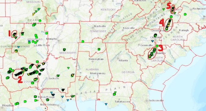
Practically the exact same prediction was made for a week prior, and that storm system actually lived up to its billing. The center of the low indeed traced a line across Kansas, dumping heavy rain and snow north of the line. The severe drought in western OK helped form a dryline along I-35, and supercell thunderstorms sprang up east of this line in Oklahoma and Texas. They strengthened and spawned numerous EF0 and EF1 tornadoes in Arkansas, Louisiana, and Missouri during the evening and overnight hours of 4/13, headlined by an EF2 tornado downwind of Fort Smith, AR and a long-track EF1 that cut through the center of Shreveport and Bossier City, LA. Other notable urban touchdowns from this system as it continued east were an EF2 in Meridian, MS on Saturday 4/14 and a long-track EF2 starting in Greensboro, NC (interestingly, this same supercell produced the strongest tornado of the year a couple hours later, an EF3 outside of Lynchburg, VA). This outbreak of over 30 tornadoes in 3 days continued the trend of the strongest tornado activity occurring in the proximity of cities or large towns.
Damage reports from last weekend’s tornado outbreak, highlighted by 1) Mountainburg, AR EF2 tornado, 2) Shreveport, LA long-track EF1, and one storm that produced an 3) EF1 near Columbia, SC, 4) EF2 in Greensboro, NC, and 5) EF3 tornado near Lynchburg, VA.
All in all, I think our long-term forecasts are just fine. It’s much easier to predict the exact positions of these storm ingredients 2 or 3 days out, which still gives emergency management crews and others time to prepare for an event. But we still don’t know where a tornado will form within this convective environment until minutes before (many storm chasers flocked to Kansas and Iowa for the 4/13 storms only to be 300 miles from the closest tornado touchdown): another reason I’m excited to be researching small-scale local effects on tornado development!
Edit: an addendum about how the Pacific Ocean surface temperature is likely involved in this April’s weather
One 24-hour layover. Two UNESCO World Heritage Sites. Lots of great food, drinks, and conversation. A wonderful tour of a beautiful city. Oh, and the Panama Canal. Here’s how it all happened:
When Clayton and I saw that our budget flights to Peru required an overnight stop in Panama City (Panama, not Florida, for you americanos), we looked at each other without a moment of consternation and said “let’s do this!” It was a no-brainer: Panama doesn’t require a visa for U.S. travelers, he already had a friend who lives there in Ana Gaby, and they have a canal that’s, you know, pretty famous. A couple months later, here we were on a muggy Friday evening, readying for a night out in the city with the tallest skyline in Latin America.
Panama City’s modern skyline, as viewed from our hotel atrium
After our very affordable 4-star hotel on Punta Paitilla welcomed us with complimentary rum cocktails, we headed to the historic Casco Antiguo district for the night. Built over 300 years ago, the colonial town center now houses a world-class restaurant and bar scene reminiscent of New Orleans’s French Quarter but with an air of Spanish imperial toughness and sophistication. We dined on “new Latin” cuisine, a variety of exquisite tapas with Central American, Caribbean, and European flavor influences. In the street, we witnessed a procession of the Virgin Mary with costumed followers and a marching band. We caught cursory glimpses of the old town squares, government palace, and the Victorian-era national theater as we made our way to the other, slightly less esteemed Teatro Amador: a discoteca where we danced forgettably (there was an open bar) to mostly American music.
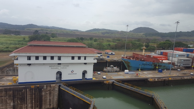
We started the next morning with empanadas, a Panamanian specialty stuffed with a variety of savory meat and vegetable fillings. Then we headed to the Panama Canal, which you can see very well from the visitor center at Miraflores Locks. The museum entertained us until two boats pulled up to the locks, which were built along with the original canal in 1913. It was really cool to see these two massive cargo ships lowered over 50 feet as 100 million gallons of lake water were released to the Pacific, just 2 of over 10,000 ships to annually traverse the canal responsible for around 5% of all shipped goods worldwide.
A cargo ship moving through the Miraflores Locks on the Panama Canal
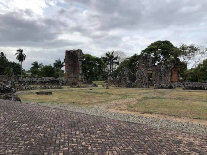
Our friend Ana Gaby took us out for an authentic Panamanian lunch, where I tried ropa vieja (decadent stewed beef barbacoa) and Panama beer (just beer). A driving tour of the rest of the city brought us out on the causeway to Punta Culebra, where we passed the distinctive, colorful Biomuseo designed by Frank Gehry as well as magnificent views of the entire skyline across the bay. In the spirit of enjoying all things Panamanian, we drove around with the radio playing music from Panama’s own Comando Tiburón and Llevarte a Marte. We finished the tour at Panama Viejo, a charred ruin of the 16th century city that could have been the oldest continuous settlement in the New World if it weren’t preemptively burned to the ground under the threat of a pirate attack in 1670. Crazy bit of history, and crazier to think about what could have been there.
Panama Viejo, where even the cathedrals were burnt to the ground in 1670
Before we could leave for good, we made an obligatory stop for shaved ice, a delicious refreshment of passion fruit puree, condensed milk, malt, and ice that the man physically shaved from a giant ice block…so authentic! All in all, it was a wonderful visit, and I feel like I got to know Panama City quite well for a day’s visit. While carefully preserving pockets of history and culture, it is ultimately a modern, international city, and I now understand how a foreigner could live there for 4 years without feeling compelled to learn Spanish (true story, apparently). Shoutout to Ana Gaby – and Manuel and Stephanie – for making our short time in Panama incredible!
Friends and shaved ice are essential for a fun time in Panama
It’s Day 4 of the Great Oklahoma Teacher Walkout, and the strike appears to finally be reaching a climax. Each day this week, tens of thousands of teachers, students, and concerned citizens have congregated at the State Capitol with signs and songs and slogans, some of which have made waves on national and even international news. On Monday and Tuesday, demonstrators were met with mainly deaf ears and closed doors within the Capitol, with some lawmakers vowing not to make any concessions to “paid protesters” and the governor comparing the teachers to “teenagers wanting a better car.” But Wednesday marked significant progress, as the House introduced a bill that would finance a $20 million increase to classroom funding in addition to the $50 million previously approved for teacher salaries. The continued march has, at the very least, commanded the attention of our state lawmakers to the dire decline in educational outcomes that have Oklahoma ranked in the bottom 5 nationwide by practically every metric. So how did we get here?
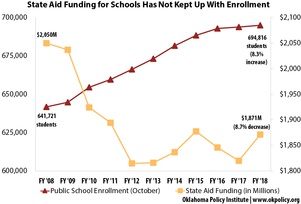
Starting in 2008 and culminating with the election of Gov. Mary Fallin in 2010, Oklahoma Republicans rode a wave of pro-business sentiment to a super-majority that slashed taxes and ‘wasteful spending’. The 2009 federal stimulus package supplanted $425 million of the state’s funding for education, and the ‘no new expenditures’ government essentially made this a permanent cut in 2010. Revenue declined as state tax breaks gave the energy industry the lowest overall production taxes in the country. When the price of oil crashed in 2014, the state had record budget deficits of nearly $900 million (15% of the state’s operating budget, which caused the state to declare a ‘revenue crisis’). Rather than raising taxes to make up a portion of the $250 million yearly deficit, the state legislature instituted a lottery, but this fell short of projections in only generating around $30 million a year for K-12 schools. The following graph tracks state education funding as the state has failed to raise teacher pay or classroom aid since I was in high school:
Lawmakers expected a ‘thank you’ rather than a strike for this year’s $50M ‘historic increase.’
What’s the solution? Well, a state that has experienced such tremendous growth and progress over the last 15 years should not settle for a bottom-of-the-barrel education system. I think that the approved $6100 average increase in teacher salaries – which raises teacher pay to be competitive with the second-lowest state salary in the region, Missouri – combined with the House’s $20 million per year boost to classroom funding represents a Band-Aid that might be big enough to stop the bleeding. But Oklahoma’s classrooms are 10 years behind on many textbooks and supplies, a reason why teachers are asking the state government to make up the entire $200 million that was previously cut. A long-term strategy to modernize Oklahoma’s classroom, investing in student laptops, e-textbooks, and online resources, would likely save money in the long run while better preparing students for the professional world of the 21st century (after all, practically every college assignment and professional project of mine has required a computer). And of course an investment in quality teachers is essential, as I believe that every child deserves a teacher who can inspire as well as inform them, no matter what state or school district they grow up in. I’ve become somewhat of a one-issue voter, and I’ll gladly support any new candidates who stand for a strong and equitable public education system. So that the next generation can get it right, in Oklahoma and beyond.
Even though I left Peru a week ago, my mind is still down there somewhere. Reliving the breathtaking mountain views instead of digesting long-term storm forecasts. Craving 2000-calorie feasts of meat, fish, potatoes, and rice like I’m still on the trek. Head-bobbing to South American music instead of writing code. Formulating sentences in Spanish when I need to write this post in English. So much for coca leaf tea stimulating one’s focus… anyway, here’s my halfhearted attempt at distilling my observations, only because I can’t share every moment of those epic two weeks.
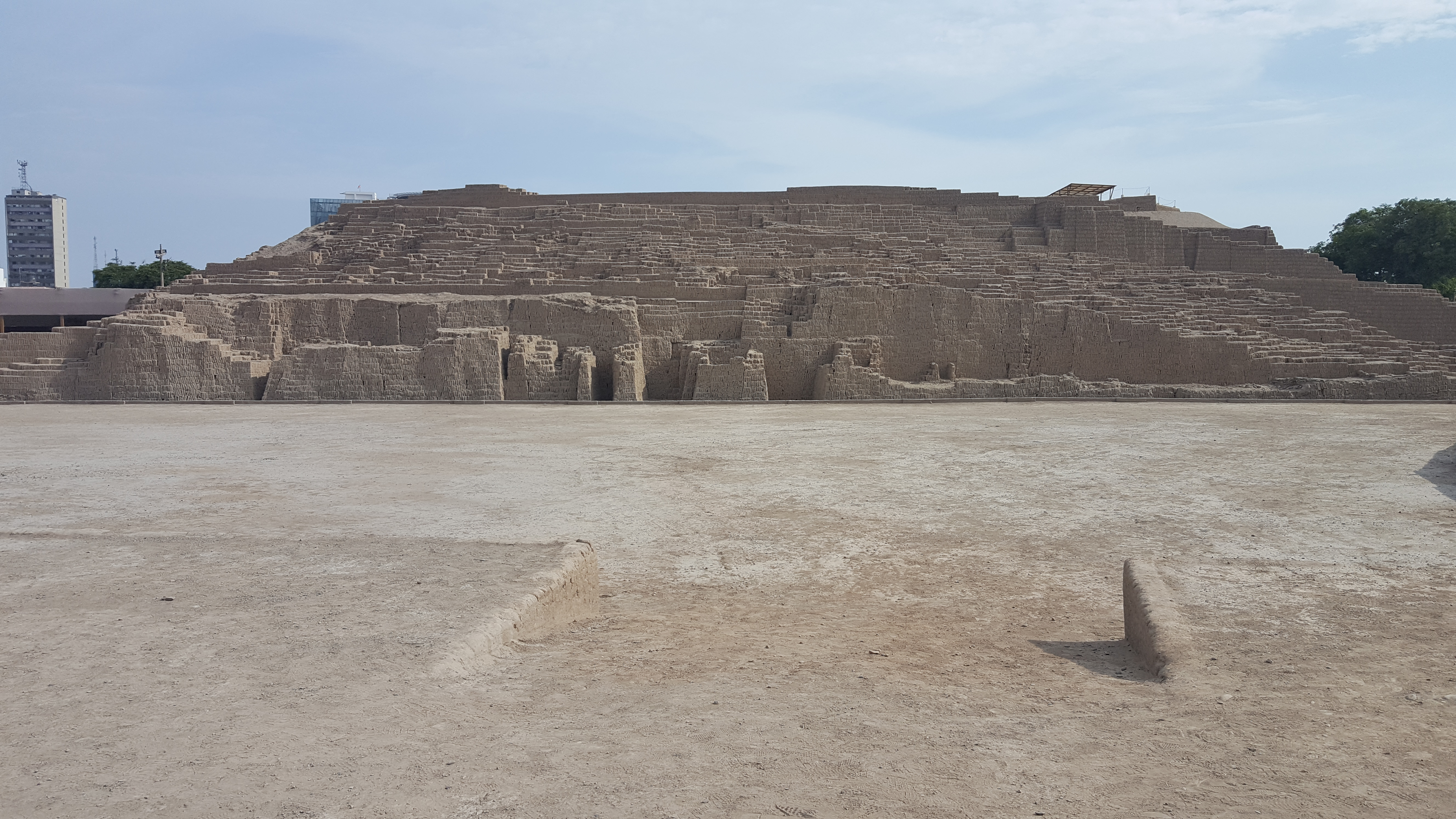
Huaca Pucllana pyramid in Lima, built around 500 AD
My buddy Clayton invited me on a trek to Machu Picchu, so we built an action-packed itinerary to span his entire 2-week spring break. We spent the first two days in Lima, a city of around 10 million best known for its world-leading culinary scene. Its history goes back many centuries, as we found out at Huaca Pucllana, an ancient pyramid built by the pre-Incan Lima culture that now stands precariously within the shiny high-rise blocks of modern Miraflores. The thousand-years-younger Spanish colonial architecture around the Plaza de Armas was impressive in its own right, as the cathedral, presidential palace, and bright yellow government buildings commanded 360 degrees of selfies. At noon, we watched the changing of the guard, a fascinating choreography of soldiers swapping places in formation to the accompaniment of a marching band. We also toured the catacombs beneath the Convent of San Francisco, where 30,000 colonials were once interred but have since been excavated into sorted piles of bones. Because several museums downtown were closed for some unexplained reason, we skipped straight to the beach, where I promptly fell into the Pacific. Life experience beckoned. Hey, the views along the Malecón in Miraflores and Barranco are to fall for!
A Pacific sunset while sipping a chilcano in Barranco
About the famous food: in order to try everything, we took a highly recommended food tasting tour in the artistic neighborhood of Barranco. There we sampled the revolutionary causa (tuna/octopus/scallop ceviche served on a pillow of creamy potatoes, i.e. the leftovers served to soldiers during the late-19th century war with Chile), savory anticuchos (grilled marinated cow hearts), classic lomo saltado (Chinese-style stir-fry of beef, bell peppers, and onions), refreshing Inca Kola and emoliente (drinkable health goo made from 30+ fruits, vegetables, flowers, and herbal remedies), and a bevy of Pisco-based cocktails. We satisfied our seafood cravings with a stop for ceviche, local snapper, and the best tasting lobster I’ve ever had (it was braised with pisco and cream and parmesan then stuffed back into the shell…superb). A late night at the hostel parties in town was followed by a fresh guanabana smoothie for recovery. We barely scratched the surface of Chifa and Nikkei cuisines, which are Chinese and Japanese cuisines, respectively, that incorporate native Peruvian ingredients like potatoes, corn, and local meat and fish. But the rich blend of highland, jungle, and sea in every dish certainly left an impression of why Lima cuisine is regarded as among the best in the world.
Meeting the photogenic and charismatic president of the Uros Islands
After a quick flight to Puno, we boarded a boat for a 2-day tour of Lake Titicaca. First stop were the floating Uros Islands, where tourism currently props up about a thousand people living for the most part as they have for centuries. The story goes that as the Incas conquered much of the Andean region, the original Uros were chased off the mainland to begin building floating villages out of the totoro reed. It takes a year and a half to construct new islands, between harvesting and drying the root ball foundations, balancing and anchoring, then adding 2 meters of stacked reeds for the all-purpose, springy floor. We met the president of the island, Lorenzo, who consented to answer a few of our questions in Spanish in return for buying curios. He lives with his wife and 4 daughters in a compound with several small buildings for sleeping and living, and an outdoor kitchen lean-to where a pan was simmering with 20 or so small lake trout. Technology has infiltrated their primitive lifestyle in the form of solar/battery units for night lighting and refrigeration, agricultural products from the mainland, and the top-ranked primary school in the Puno region. Nevertheless, it was profoundly interesting to see the preserved culture of the Uros people firsthand.
Most views of Amantani Island are this breathtaking and pastoral
The boat continued to Amantaní Island, where we spent a day in the home of Nemesio and Matilda. The traditional lunch began with a quinoa-based soup that tasted just like my grandmother’s chicken noodle soup then finished with a simple entree of fried alpaca cheese atop a bed of brown rice. We then hiked up to the temple of Pachatata at the top of the island. From there we could see the entire island, terraced all the way down to the deep blue lake and dotted with stacked stones from centuries of civilization. After a home-cooked dinner, the family decked us out in traditional garb (for men a gray woolen poncho and a knit hat, but for our friend Patrycja it was a 10-minute process of pushing and pulling on a colorful skirt, tights, and shawl) and we proceeded to the ‘discoteca’, where we danced the night away to an Andean band that played, among other things, Despacito. The next morning, after a hearty breakfast of soup and pancakes, we said goodbye to our gracious host family (they really were wonderful people – though they have frequent foreigner guests, we conversed beyond the surface level in Spanish. And their 11-year-old daughter was very sweet, I couldn’t help but leave her the Spanish translation of a Sherlock Holmes anthology that I was reading to practice).
The next stop was Taquile Island, another ancient terraced island with spectacular views of the Isla del Sol and snowcapped mountains across the lake in Bolivia. After a delicious trout lunch, we made our way back to the shore where our guide dared the tour group to jump in the lake. I realized I was the only one to take this challenge seriously when I was wading past the sandy shore alone…but diving in was so refreshing and exhilarating that I soon had a crowd of new friends jump off the boat to join me. Life experience, I swam in Lake Titicaca! The frigid lake energized me for the 3 hour journey back to Puno, where we spent an evening with new friends awaiting our overnight bus to Cusco. We stopped in the shop of a luthier, where I semi-impulsively purchased a handmade, 10-stringed charango to add to my collection of string instruments. We then went out for roast alpaca and cuy, or guinea pig (according to tradition, families will have guinea pigs running around their kitchen for roasting when an unexpected special occasion arises. It tasted a bit like chicken but was infinitely harder to eat.) When an Andean band walked into the restaurant to serenade the patrons, they invited me up with my new charango, so I brought all 2 chords that I had learned and…tried…to fit in and harmonize. It was a dream fulfilled, really. Life experience.
Crooning with a charango at the base of Mt. Salkantay
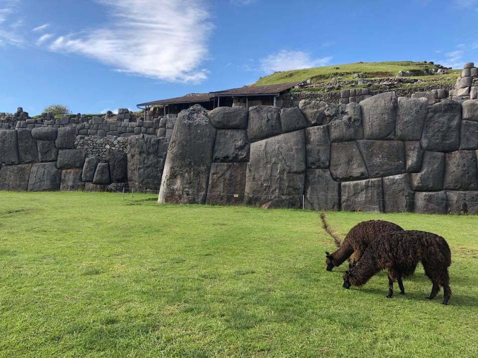
We arrived in Cusco at the crack of 4:30am (our overnight bus was positively luxurious, so I was able to get some sleep on the way). Rather than resting up for our trek, we set off a few hours later for a full day of tourism around the historic city. We made a stop at Sacsayhuaman, a hilltop ruin famous for its massive square stones and seemingly impossible engineering. In fact, one of our cab drivers suggested that the many pre-Incan ruins in the Peruvian Andes may have been built by God or by aliens, which is just as well since the Incas left no written records and our guides were often a bit loosey-goosey with the facts. After a quick stop at the Christ the Redeemer statue, we descended to the picture-perfect Plaza de Armas. There, we went inside the two cathedrals, the larger of which had a couple of recesses devoted to the Lord of Earthquakes, a charred-black crucifix that was purported to protect several key structures in Cusco from complete destruction during the 1650 earthquake. A period mural shows the collapse of the colonial Spanish capital – interestingly, the Inca foundations remained relatively intact. First-person accounts of a 350-year-old natural disaster tucked away in religious iconography?! I was captivated. We then saw these Inca foundations in person at Qorikoncha, the former Inca palace that is now a museum for ancient art and artifacts. We also spent a couple hours at the San Pedro market, where you can buy any craft item imaginable. We gorged on a street food feast for 2 that ended up costing about $3, capping it all off with custard apple and lúcuma smoothies.
Giant stones at Sacsayhuaman, with Peruvian landscaping crew
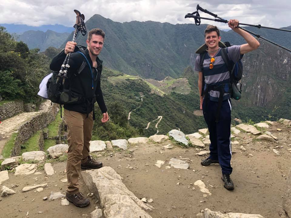
For the next week, Clayton and I went on the trek of a lifetime. Sifting through my journal, it’s clear to me that I’ll need to chronicle the journey fully in a future blog post. That’s what happens when you pass so many interesting landmarks and beautiful vistas. We climbed to the placid Humantay Lake, slept in a glass dome in the clouds, hiked to the base of the 20,000 foot tall Salkantay Peak, sat atop a steep glacial arête, had a snowball fight on a glacier, built apachetas on a blustery ridge at 17000 feet, camped with llamas, conquered the “gringo killer” hill on the Inca trail, saw countless ancient ruins and mountain views, then finally passed through the Sun Gate to behold Machu Picchu. We were incredibly lucky with the weather, especially considering it was the rainy season: it poured on us twice, but we lucked out with spectacular views of Machu Picchu, the Urubamba valley, and the Salkantay Range. It’s a cliché to say these views were indescribable, but they’re the kind of scenes that make you gasp in person, reach for your camera, take a perfectly framed snapshot…then when you’re perusing the photos with a friend days later, you gasp again at the memory while they say flatly, “Yeah, that’s pretty nice.” All I can say is, go, get this life experience for yourself! And preferably during the dry season…we could easily have been rained out as were many of the other travelers we met.
The end of our weeklong trek, until we hiked down to Machu Picchu
We capped off our Peruvian adventures with a day trip to Rainbow Mountain, which was fittingly spectacular and worth the 3:30am bus pickup. The nice breakfast and tea nearly became a liability as we wove up the most dangerous, precariously cut one-way gravel road to the trailhead (in a bus, mind you). A swarm of Peruvian caballeros met us at the gate, but we declined a horse ride to walk the 3 miles to the summit. The tallest mountain in the Cusco area, the majestic Ausangate, rising over 20,900 feet, showed its icy peak through the clouds as we neared Rainbow Mountain. An hour and a half later, we arrived at the summit, though breathless at 17,000 feet. The colors of the mountain need no filter, they really look like that in person. The patches of sun created a stunning visual effect as the clouds gradually overtook our mountain. After taking pictures until the bitter winds numbed our fingers, we set off down the mountain, chased by driving rain and sleet. Again, nice weather shined on us just long enough to see the rainbow, take excessive numbers of pictures from all angles and poses, then rush down.
Rainbow Mountain, before the rain
I would be remiss not to talk about the people I met along the way, as I have been thinking about them at least as much as the sights and flavors. I had a wonderful time getting to know Carolina from Ecuador as we fought mud, wind, rain, and sleet coming down Rainbow Mountain, as well as meeting new friends from Brazil, Argentina, Uruguay, Toronto, and Lima. Our tour guides were fantastic, and I’m still in touch with Daniel from Lima (who gave that phenomenal food tour but also peppered us with great recommendations for the rest of the trip), Miguel from Lake Titicaca (who gave the best bilingual tour on Lake Titicaca, 5 words Spanish then the exact same 5 words in English…mostly), and of course Wimber who we got to know very well during the trek. Cassidy and Megan from the west coast who we shared a victory dinner with after the trek. Solo backpackers Patrycja from Poland and Cora from New Zealand who continued their specific adventures in Bolivia after our island homestay. The Vivanco family from Lima, who reminded me so much of my own family though we grew up on different continents: Leonardo, a polite and mature engineering student with a knack for his photography hobby, and his free-spirited younger sister Camila traveling with their lovely parents on an annual family vacation. Cristian, my new meteorology friend in Lima. Countless other travelers that I met from all over the world along the trail, on tours, at parties, you name it. The magic of Facebook means I’ll know when I cross paths with any of these friends again, since we’re in touch from our various corners of the world.
Everyone I met, both travelers and locals alike, had bought in completely to the culture of friendliness. All the hotel and tour agency staff members that I interacted with gladly went out of their way to help us get the most out of our experience. Even our scammer in Lima was pleasant: a man came up in the Plaza de Armas and energetically introduced himself as Tupac, presented us each with woven armbands and llama keychains, accompanied us to lunch where he ordered a round of pisco sours and Cusqueño beer, answered some insider questions about life in Lima and his childhood in the Andean highlands, gave me a surprisingly good neck and head massage, then proceeded to charge us $20 for his “services.” Life experience. Everyone is friendly, but many of the cab drivers, wait staff, vendors, and ‘volunteer’ tour guides can be sneakily enterprising (to downright predatory, by American standards anyway). Once you learn to ask the price before accepting a service, and to politely decline the barrage of massages and other less-than-useful goods peddled to you, traveling in Peru is affordable and loads of fun! Usually I travel as if I’ll never return to a place, but since leaving Peru I have been scheming my next visit. It’s a special place with special people, and I’ll be back.


 Lawmakers expected a ‘thank you’ rather than a strike for this year’s $50M ‘historic increase.’