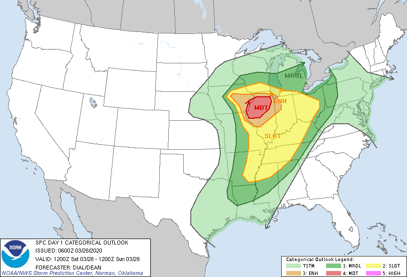
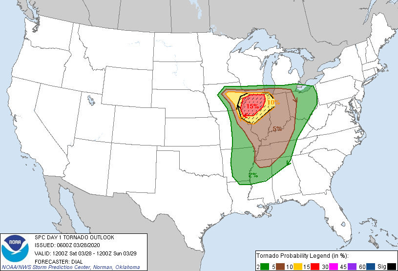
Beginning yesterday, the Storm Prediction Center began issuing ominous warnings for today’s severe weather in northern Illinois. Most of the ingredients were already in place: a warm front pulling humidity from the south, a very strong mid-level jet from the southwest, and a steep lapse gradient above the cap. A practice round of storms sprang up across central Illinois last night, wetting the land with brief bouts of heavy rain and small hail. This morning, the SPC issued a rare “Particularly Dangerous Situation” tornado watch, with a moderate (15%) chance of local tornadoes depicted in the 12Z convective outlook.
Warnings this serious only happen a few times a year for the entire country, isn’t it too early in the season to have tornadoes that far north? A Midwestern severe weather outbreak at this time of year isn’t without precedent. In fact, one happened on this exact date, March 28th, 1920. The first of the infamous “Palm Sunday Outbreaks” brought an estimated total of 37 tornadoes to Illinois, Indiana, Michigan, Wisconsin, Ohio, Alabama, and Georgia. Without radar or broadcast news coverage, over 380 people were killed. In today’s terms, that’s a staggering toll, more fatalities than every tornado outbreak since 2012 combined. Thankfully, our long-term and short-term warnings have come a long way.

In a stroke of good fortune, today’s setup did not turn into the historic outbreak that many expected. Lingering morning showers cooled the surface layer, then cloud cover prevented insolation to the land surface. For topographical heterogeneities to play a role in tornado formation, differential heating at the ground level is practically a requirement. I ran my computational model for the northern Illinois, even exaggerating the sun exposure over the domain. Didn’t matter, the low-level environment was not energetic enough to explode through the mid-level cap. Thus, the parent thunderstorms that eventually formed lacked the energy or rotation to sustain long-track tornadoes, instead dropping a few brief twisters downwind of the Rock River and Illinois River valleys.
There were larger tornadoes that hit Jonesboro, Arkansas and Waterloo, Iowa; though outside the hatched area, these places were still under a severe weather watch. Both areas received several hours of sunshine before the storms rolled in, so perhaps the forecasting lesson is to never underestimate the impact of cloud cover on suppressing severe weather. As I incorporate more complete cloud cover data into my program, I will be very interested to examine the effects of land surface shading on atmospheric flows. In the ongoing quest to determine why specific thunderstorms develop tornadoes and others don’t, there may be insights in the sunlight.
