Topography and Tornadoes: a Recent Case Study

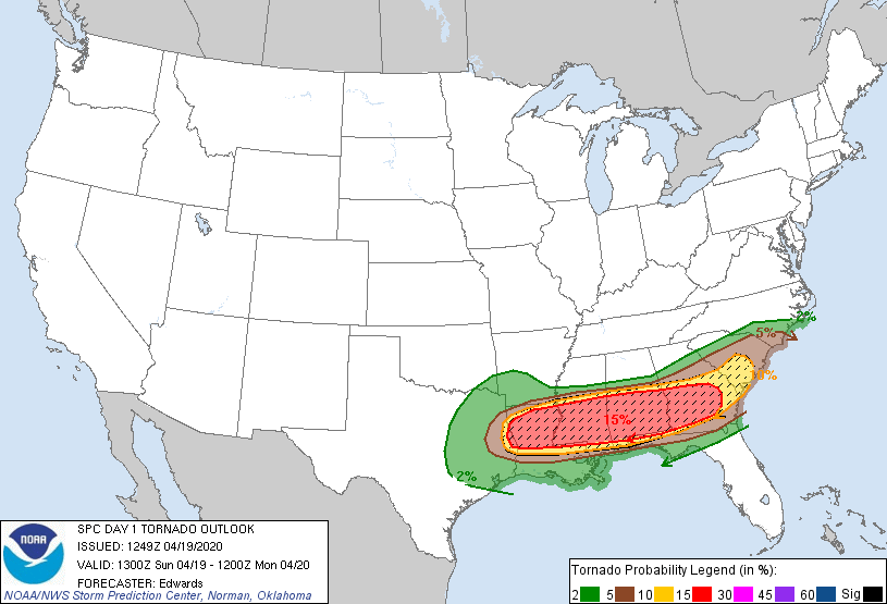
In the ten years since I became interested in this question, there have been several significant advances in understanding the influence of topography on tornado development. The Midwest, a region known for flat and boring terrain, serves as an ideal testbed to observe these influences, offering the ability to isolate topographical variables against a flat control domain. This post seeks to identify topographical drivers and assess the physical mechanisms within a recent tornado outbreak that spawned over a dozen tornadoes across Ohio, Indiana, and Illinois on March 14th.

Zooming out to assess all possible terrain variables, Kellner (2012) first employs GIS methodologies to establish statistical correlations between tornado touchdown points and several spatial features: elevation, land use, surface roughness, antecedent rainfall, and more. Using a high-resolution buffer analysis, the study highlighted that 64% of all tornado touchdowns occurred near urban land use and 42% near forests, a moderate-to-strong correlation given the overwhelming presence of flat farmland and range. The consensus explanation for this correlation is that increased surface roughness causes more horizontal vorticity that can contribute rotational energy when advected into a tornadic storm via the streamwise vorticity current, though I would also posit that urban heat island effects can add significant energy (localized SBCAPE) as well. A strong example of this formation mechanism occurred when a tornado coalesced downwind of Muncie, IN as an EF2, briefly lifted off the ground over Farmland (that’s a town name, though the terrain type is implied), then churned at up to EF3 strength for another 40 miles into Ohio.

Selma, IN (EF2) and Winchester, IN (EF3) tornado damage paths from the evening of 3/14/24 (NWS)

To dive deeper into the physics of tornado-ground interactions, Satrio (2020) experiments with a well-established LES model to simulate how a tornado-like vortex moves over various hill configurations. Near-ground flows have been a popular research topic for their damage potential and effects on vortex stability, inspiring numerous observational studies using radar, photogrammetry, and debris impact analysis. Satrio’s simulation results paint a particularly cogent picture of tornado dynamics, how uphill slopes can cause a low-level vortex disruption, how downhill slopes cause an intensification of swirl, and how vortices can bend to remain perpendicular to sloped terrain. All three of these effects can be clearly observed in the tornado that touched down near Hanover, IN: after crossing the Ohio River, the tornado weakened to an EF0 at the top of the first ridge, intensified to an EF2 as the track turned to follow the southern edge of the valley, weakened back to an EF0 over the second ridge, and reintensified to an EF2 upon crossing the valley again. Variations of this tornado evolution behavior have been corroborated numerous times in recent literature, most clearly by Lyza and Knupp (2018) on the periodic ridges of northeast Alabama, Bosart (2006) in the Hudson Valley, and Wagner (2018) near the Kansas River.

Hanover, IN tornado (3/14/24) damage path strongly influenced by Ohio River valley terrain (NWS)

However, tornado damage paths do not always show such visible signatures of terrain influence. Sometimes, as in the brief EF2 tornado near Plymouth, OH, there are absolutely no interesting topographical features in sight (though I would argue that the absence of terrain heterogeneities likely prevented further intensification within this supercell). In other instances, inferences about the nature of storm inflow would be needed to consider any terrain interactions. For example, the long-track tornado that struck Lakeville, OH as an EF3 does not have any significant hills, cities, forests, or geographic boundaries along its path. But, when the initial EF0-EF1 tornado crossed Grand Lake, the vortex was turned northward to favor the inflow side. Several miles later, likely due to the increased humid inflow, the tornado reformed as an EF3 near Wapakoneta and rumbled for almost an hour toward the northern suburbs of Columbus. The presence of the urban/suburban roughness on the inflow side, along with the Scioto and Olentangy River valleys, likely gave this tornado the extra push to reform as a long-track EF1 near Delaware, OH. These terrain influences are more subtle and speculative, of course, but the potential for these types of observations sparked my interest in tornado simulation and prediction in the first place. I firmly believe that localized surface conditions play a major role in the formation of not just tornadoes but many weather phenomena, and it’s always gratifying to find physical evidence in support.

Grand Lake, OH EF1 tornado that preceded the Lakeville, OH EF3 on the evening of 3/14/24 (NWS)

Delaware, OH long-track EF1 tornado formed from the remains of Lakeville, OH tornado (NWS)

Bunch of nothing around Plymouth, OH EF2 tornado path, 3/14/24 (NWS)

Tornado path maps from the NWS Damage Assessment Toolkit, preliminary data

The Chaos of Massive Supercells

A rather unexpected disaster sprang from a ‘slight’ risk the other day in Oklahoma, as several supercells erupted within an energetic warm sector ahead of a slowing cold front. While the northern cells produced hail as they drifted to the northeast then dissipated, the three southernmost cells merged to form a large, rapidly cycling storm (radar loop linked) that would drop 13 tornadoes in 90 minutes, including an EF3 that devastated the town of Cole and an EF2 that wrought extensive damage upon Shawnee. Sometimes called ‘mothership’ supercells for their impressive rotating cloud formations, these storms often form over the high plains where land surface homogeneity favors large near-laminar inflow regions. In contrast to the predictable linear paths of tornadoes within typical supercell or QLCS thunderstorms, these massive supercells produce tornadoes that revolve around a central vortex, fanning out on highly chaotic paths. The tornadogenesis is clearly top-down from the large parent vortex, and the wide inflow largely smooths the effects of any topographical heterogeneities.

10+ tornadoes from a single supercell in central OK, 4/19/2023. NOAA Damage Assessment Toolkit

Rather than belabor my land surface model with a scenario where tornadoes evolved independently of terrain, I want to draw comparisons to tornadic events in recent memory, specifically a pair of events in 2017 when I was just beginning my deep-dive into tornado modeling and prediction. First, on April 14th, a mothership supercell formed in the Texas Panhandle then parked near Dimmitt, cycling in place for three hours and spawning several tornadoes including a mile-wide EF3 wedge outside of town. This spectacular parent supercell made another appearance on this blog for its textbook bubbling outflow as observed by the GOES-16 satellite. Then, just two weeks later, Canton TX was besieged by an analogous storm, a massive rotating supercell that spawned a couple of long-track tornadoes (EF3 and EF4) that ground chaotically northward over the course of more than an hour. While these three examples will be further examined as top-end tornadic events, mega-supercells (is this a good term, or do we need even more prefixes?) that produce several tornadoes are vanishingly rare, responsible for roughly 1% of all recorded tornadoes in the last decade. Worth studying, certainly, but I believe they deserve their own category distinct from conventional supercells because their behavior is so uniquely unpredictable.

Little Rock Tornado 3/31/2023

Perhaps the most predictable tornado in my memory struck Little Rock, Arkansas on Friday afternoon, causing widespread damage and dozens of injuries. The Storm Prediction Center issued a rare “Particularly Dangerous Situation” warning and the convective outlook showed a large swath of Level 5 hazard risk (the highest) from central Arkansas northward into much of the Midwest. Part of a large outbreak of over 100 tornadoes across the warned region, this particular tornado was preceded by radar-confirmed lowerings near Hot Springs about an hour prior to touchdown, prompting a tornado warning with an above-average lead time of 21 minutes. As the storm crossed over some hills into the west Little Rock suburbs, it spawned a high-end EF3 tornado with winds up to 165 mph along a 34-mile path of destruction that crossed the entire metropolitan area.

Zooming in on the beginning of the path, the pre-established rotation intensified after passing over a valley of sheltered air then touched down as a wedge tornado after clearing Ellis Mountain. Presumably, the air in this valley was warmer relative to the surroundings, carrying an additional >100 J/kg of surface-based CAPE (convective available potential energy) when it was forced into the inflow by the topographical obstruction. When cooled, this air mass would contribute to the pressure fall inside the vortex, tighten the rotation and increase the kinetic energy (read: velocity) of the rotating winds. The computational model that I started this blog in part to document specializes in forecasting this exact scenario, quantitatively simulating the gradients in surface temperature and humidity that affect characteristics of the inflow.

Of course, the three-dimensional simulation of a tornado within a parent supercell is computationally expensive, essentially requiring a supercomputer even for a restricted domain. Even generating the differential temperature map can prove challenging, both due to computational demands and because slight deviations in input parameters can yield significantly different results. Perhaps a more practical approach than on-demand simulation would be to aggregate a range of possible pre-storm environments into a base layer that can readily be created/used by forecasters – call it a “tornado intensification risk” map for generalized conditions. While my land surface simulation work garnered only tepid interest from meteorologists and academics, the prospect of this type of hazard map piqued the interest of several representatives for insurance companies. Not that insurance rate adjustment is the only application for this type of information – in the time that this project has sat on the back burner as my life became more hectic since 2020, the idea of an aggregate data layer for tornado risk has grown on me for public access in forecasting and emergency preparedness, sacrificing scientific specificity for ease of use.

An open-access risk map for tornadoes, even as a developmental release, would be highly beneficial, especially for urban areas where tornado strikes pose an elevated threat to life and property. Little Rock was highlighted in my preliminary simulation-based testing as having a tornado risk higher than its surroundings, part of a short list that included Birmingham, Nashville, Louisville, and Tulsa. Smaller cities with elevated risk included Rome (GA), Gadsden and Tuscaloosa (AL), Conway and Fort Smith (AR), Joplin and Cape Girardeau (MO), Quad Cities and Peoria (IL), among a few others. Locations downwind from the highlighted population centers would benefit from this information as well: the town of Wynne, Arkansas was leveled when the same parent supercell regrouped to spawn another long-track EF3 tornado that stayed on the ground for over an hour and carved a track of desolation all the way to Tennessee. For a number of reasons, a comprehensive yet accessible terrain model would be a worthwhile tool for improving tornado forecasts, and while it wouldn’t prevent tragedy outright, it could certainly help to warn people in harm’s way.

The Infamous Quad-State Tornado

Last night, tragedy struck in the form of the most devastating tornado in a decade, killing over 70 people in Kentucky and reducing several whole communities to rubble. This was possibly the longest continuous tornado track in recorded history, originating near Jonesboro, AR and crossing portions of Missouri and Tennessee before unleashing its worst damage on a large swath of western Kentucky – an estimated 227 mile path of destruction. Though we will know more about the death toll, EF-rating, and official path length once emergency crews and NWS survey teams fully sift through the wreckage, this was undeniably one of the worst tornado disasters of my lifetime.

Early comparisons for this event all point to the Tri-State Tornado of 1925, the worst tornado in history. That tornado destroyed 164 square miles including several towns, as it rumbled a 219-mile path from southeast Missouri into southern Indiana. A mile wide behemoth traveling up to 70 mph, that tornado stayed on the ground for 3.5 hours and killed 695 people. Modern warnings and F-scale ratings, still a few decades from inception, would have reduced the death toll and helped us truly compare these disasters, but the Tri-State Tornado would no doubt be a monster by today’s standards as well. Below is a preliminary path comparison of these two long-track tornadoes:

The “Quad-State Tornado” preliminary track (above) compared to the Tri-State Tornado of 1925

If you ask me, there may be an elevated likelihood for a long-track, multi-state tornado to occur in the upper Delta region. For starters, there are a lot of states packed into a relatively small area. But my argument is more tied to the physical geography – the Mississippi River meanders through an extremely flat floodplain where low level air is likely to be humid, either from local standing water or advection from the Gulf of Mexico. This warm, moist air can be occluded by the Ozarks to the west and the Appalachian foothills to the east, enhancing convection from the surface that would be exacerbated in a convective meteorological setup. Last night’s setup featured a particularly strong jet streak, fast-moving dry air at the mid-level of the troposphere that maximized lapse rate values and initiated the severe storms along this orographic boundary.

The National Weather Service was on top of this outbreak, identifying severe weather potential about 5 days in advance, issuing a tornado watch across the domain by 3pm on Friday, and providing tornado warnings a commendable 30-45 minutes ahead of the largest tornado. However, as with most of the deadliest tornadoes, poor warning communication remains a major hurdle for risk mitigation – the most fatalities occurred at a candle factory in Mayfield, KY where night shift workers were “sheltering in place,” largely unaware of danger until the roof caved in. Likewise, another tornado in this outbreak killed several workers at an Amazon fulfillment warehouse in Edwardsville, IL. I hope that these mass casualty incidents inspire a seed change in how emergency notification is carried out in industry, since ignorance is inexcusable with the abundance of warning communication via smartphone. And I hope that the impacted communities can recover, with help, from this historically terrible disaster.

An Odd Tornado Trend

The 2021 tornado season is already in full swing, with back-to-back weeks of high-risk convective outlooks in the Southeast. Numerous supercells spawned significant tornadoes across Mississippi, Alabama, and Georgia, culminating in a tragic EF4 tornado in Newman, GA on Thursday evening. The recent rash of severe weather reminds me of a trend that I know has no scientific merit but strikes me as uncanny nonetheless. It seems like the major tornadic events of my lifetime have mainly occurred during odd-numbered years. Joplin and Tuscaloosa in 2011. Moore in 1999, 2003, and 2013. El Reno in 2011 and 2013. More recently, a rash of winter tornadoes in early 2017. Rare autumn tornadoes near Dallas in 2015 and 2019. Dayton and several others during a record wave in May 2019. As an armchair statistician with an interest in severe weather, I could make the list go on and on.

But while a list of examples does constitute an observation – a worldly observation at that – this is no way to make a scientific assertion. Experiential data can be biased based on one’s vantage point, preconceived notions, memory, or any number of factors. The cold, hard data tells the true story: that variations in tornado counts over time fall within statistical randomness. My little odd-year hypothesis was not unfounded for the last decade, though, when happenstance alone may account for spikes in 2011, 2015, 2017, and 2019 compared to surrounding years:

Annual tornado counts since 1950. The increase over time reflects progress in tornado observation and damage reporting, not climatic effects or other biases.

A count of all tornadoes doesn’t tell the full story, of course. About 90% of tornadoes are weak, EF0-EF1 rated, often brief spin-ups in larger QLCS or tropical storm systems. If we only consider the EF2 and above tornadoes, which account for more than 95% of tornado-related fatalities and economic damage, it becomes clear that 2011 was an outlier year due almost entirely to the April 27 super outbreak. 2015 actually registers as the lowest year for strong tornadoes since the EF-scale was introduced, and 2017 and 2019 only reflect slightly above average numbers of significant tornadoes:

Doppler-era strong tornadoes (EF2 and up) depict 2011 as an outlier year. Source: SPC

If it’s a trend at all, it’s a weird one that I’m willing to chalk up wholly to coincidence. Tornado climatologists have tried with limited success to link tornado occurrences to El Niño/La Niña, but that wouldn’t explain a two-year alternating cycle either. And it would be a minor trend, as off the top of my head I forgot some major tornado events during even years, like strong tornadoes in Mayflower, AR and Tupelo, MS in 2014. In fact, last year was an even year headlined by a devastating tornado in Nashville and a large outbreak that I wrote about but completely neglected to remember (there’s that bias again – my memory was distracted by the onset of a global pandemic and associated life changes). Trend or no trend, severe year or less severe year, all tornado outbreaks inflict damage and affect the people living in their paths, irrespective of whether the event is “major” or memorable. That’s why I hope for a break in the trend for 2021, a less severe tornado season and a return to more scientific analyses.

Easter Weekend Tornadoes

From Saturday to Monday, the southern United States weathered a horrible tornado outbreak, arguably its worst since 2011. Forecasters knew that a dangerous setup would be in place well over a week in advance: persistent moisture from the Gulf and a late-winter cold front were destined to collide as the jet stream was maximized along the boundary. Perhaps the most apt of the predictions I heard for this meteorologic system was “messy”: there were several modes of severe weather within the domain, each mode greatly influenced by the conditions in its vicinity.

Of course, the brunt of the messiness was felt by southern Mississippi, as back-to-back violent tornadoes formed to the west of Hattiesburg-Laurel and stayed on the ground for over an hour. The damage tracks ran parallel for over 80 miles, less than 5 miles apart, tearing apart pine forests and neighborhoods and claiming 14 lives. Some meteorologists have referred to this dual-tornado scenario as “unprecedented,” and the only similar event that I remember occurred last year in Lee County, Alabama, albeit with slightly smaller tornadoes. The first tornado goes down in the record books as the third-largest tornado ever, measuring over 2 miles wide and producing one of the most eye-popping radar signatures I have ever seen (below).

Textbook radar signature of the tornadic supercell, with a 2-mile wide debris ball and base velocities exceeding 120 mph. (NWS, GR2Analyst)

While there are few topographical heterogeneities in this region, the dual supercell setup was only possible because of a sharp meteorological boundary. To the south, the Slidell, LA NWS station registered 2000 J/kg CAPE in the mixed-layer (and over 2500 J/kg at the surface) during their 4pm CDT atmospheric sounding. However, this likely underestimates the convective potential since the cold front was stationary just a hundred miles north. Two stable supercells formed at the front edge of this boundary, devouring the warm inflow while moving laterally along the boundary. On the cold side of the boundary was a vast mess of thunderstorms. On the warm side of the boundary, nothing but a warm sunny day.

Looking across the rest of the outbreak, 100 other confirmed tornadoes occurred across 8 states during that 24-hour span. The initial tornadic supercells developed in eastern Texas and northwestern Louisiana, culminating in an EF3 in the city of Monroe, LA. The low CAPE (<1000 J/kg) observed in Jackson and Birmingham likely contributed to the tamer, rain-dominated conditions behind the cold front, though a QLCS produced a few spin-up tornadoes in often-hit places like Yazoo City MS, Tuscaloosa AL, and Gadsden AL. Overnight, there were several EF2-EF3 tornadoes throughout the eastern half of the domain, inflicting major damage in suburban areas near Chattanooga TN and Clemson SC, among others. A death toll of 34 and millions of dollars in property damage, on top of the financial and emotional stresses of the coronavirus…just devastating.

So I’ve been analyzing this outbreak with a heavy heart. The monster supercells that produce the most damaging tornadoes are also the hardest for forecasters to nail down, sadly. The HRRR, while a useful tool for giving an indication of the population and severity of storms, erroneously placed the greatest supercell risk in northern Mississippi and far northern Alabama. Despite years of intense focus on Dixie Alley with VORTEX-SE, the severe weather research community remains without answers to fundamental questions, such as what ingredients differentiate a tornadic supercell from a non-tornadic supercell from a messy line of severe thunderstorms. Warning communication has certainly improved, especially with emergency notifications going out to every smartphone, but we are no closer to solving the tornadogenesis problem in any operationally meaningful way.

The closing question, how did my modeling efforts perform? Not terrifically, but there’s reason for optimism. Because the SPC warning area was so enormous, I only ran my surface simulation in a few semi-urban areas. Gadsden was one: the EF2 that struck along the I-59 represents a prime example of the land surface influencing a tornado’s lifecycle. Tuscaloosa was another, and I was able to catch the EF2 that struck to the northeast of the city (though I was surprised that it didn’t touch down a couple miles sooner). The code encountered an error with the input parameters for the late-night, but the location of East Ridge with relation to the Chattanooga tornado indicates an orographic dependence that would be reasonably predictable. I also predicted two tornado risks that didn’t pan out, so that’s some important feedback to look at as well. Hopefully that will help me prepare for the next outbreak, which might occur this Sunday – the SPC has already issued an ‘Enhanced’ tornado risk for roughly the same domain.

SPC tornado outlook for 4/12/20, above, compared to the outlook for 4/19/20, below:

20200419 1300 UTC Day 1 Tornado Probabilities Graphic

3/28/20: A severe weather day for the Midwest

Beginning yesterday, the Storm Prediction Center began issuing ominous warnings for today’s severe weather in northern Illinois. Most of the ingredients were already in place: a warm front pulling humidity from the south, a very strong mid-level jet from the southwest, and a steep lapse gradient above the cap. A practice round of storms sprang up across central Illinois last night, wetting the land with brief bouts of heavy rain and small hail. This morning, the SPC issued a rare “Particularly Dangerous Situation” tornado watch, with a moderate (15%) chance of local tornadoes depicted in the 12Z convective outlook.

20200328 1200 UTC Day 1 Outlook Graphic
Categorical outlook issued around 7am for 3/28/2020, above, along with a significant hatched area of heightened tornado risk centered around northwest Illinois, below. (NWS)
20200328 1200 UTC Day 1 Tornado Probabilities Graphic

Warnings this serious only happen a few times a year for the entire country, isn’t it too early in the season to have tornadoes that far north? A Midwestern severe weather outbreak at this time of year isn’t without precedent. In fact, one happened on this exact date, March 28th, 1920. The first of the infamous “Palm Sunday Outbreaks” brought an estimated total of 37 tornadoes to Illinois, Indiana, Michigan, Wisconsin, Ohio, Alabama, and Georgia. Without radar or broadcast news coverage, over 380 people were killed. In today’s terms, that’s a staggering toll, more fatalities than every tornado outbreak since 2012 combined. Thankfully, our long-term and short-term warnings have come a long way.

The New London, CT newspaper from the following day offered its three cents on the outbreak: imagine the calls that were made to all of the different regional authorities to create this report. The headline underestimates the death toll by about half because information just didn’t travel very fast in 1920.

In a stroke of good fortune, today’s setup did not turn into the historic outbreak that many expected. Lingering morning showers cooled the surface layer, then cloud cover prevented insolation to the land surface. For topographical heterogeneities to play a role in tornado formation, differential heating at the ground level is practically a requirement. I ran my computational model for the northern Illinois, even exaggerating the sun exposure over the domain. Didn’t matter, the low-level environment was not energetic enough to explode through the mid-level cap. Thus, the parent thunderstorms that eventually formed lacked the energy or rotation to sustain long-track tornadoes, instead dropping a few brief twisters downwind of the Rock River and Illinois River valleys.

There were larger tornadoes that hit Jonesboro, Arkansas and Waterloo, Iowa; though outside the hatched area, these places were still under a severe weather watch. Both areas received several hours of sunshine before the storms rolled in, so perhaps the forecasting lesson is to never underestimate the impact of cloud cover on suppressing severe weather. As I incorporate more complete cloud cover data into my program, I will be very interested to examine the effects of land surface shading on atmospheric flows. In the ongoing quest to determine why specific thunderstorms develop tornadoes and others don’t, there may be insights in the sunlight.

Severe Weather’s “Second Season”

A rash of severe thunderstorms rolled across my region Sunday night, an opportunity to watch a radar broadcast instead of football and respond to quizzical messages from friends. The synoptic setup was very similar to a springtime system, with a strong south wind supplying Gulf moisture and an elevated cold front pushing in from the northwest. Especially after sundown, these storms were destructive, producing an EF3 tornado in Dallas, a long-track EF2 in a populated area of NW Arkansas, and a few brief squall-line tornadoes in Oklahoma and Missouri.

Tornadoes aren’t “typical” this time of year, but Sunday’s severe weather event certainly wasn’t beyond expectation. Tornadoes can strike in any month, particularly in southern locations like Dallas that have even experienced strong tornadoes in winter. Since severe thunderstorms require warm surface-level air, cold air aloft, and wind shear to kick things off, it’s no wonder they mostly form when the jet stream is unstable during the seasonal transition of spring…or fall. Yes, there is a statistically significant uptick in tornado occurrence during November and the latter half of October, as an active jet stream and strengthening cold fronts collide with lingering surface-level summer air.

Violent tornadoes (EF4 or stronger) are far more likely in the spring, but there’s a blip in November. (Source: ustornadoes.com)

But why are tornadoes more likely in the spring than in the fall? Meteorologists think in probabilities, so they might answer that the unstable atmospheric conditions required to generate tornadic storms are present most often in the spring. Undeniably true, but not a satisfying explanation. As an engineer, I think in representative averages: what about the mean conditions of the fall make tornadoes possible but not as likely as during spring? At this time of year, cold fronts are stronger and more numerous than warm fronts, whereas the reverse is true in spring. The fall season experiences about a third less precipitation, often limiting the surface-level moisture. The days are shorter, allowing for less surface heating. Even if the jet stream/wind shear profile are similar, the thermal instability is, at least on average, markedly lower, hence why fall storms usually fall under the severe threshold.

Fall storms can reach severe levels, however, as they did on Sunday. Fortunately, the NWS was all over it, issuing a tornado watch for an area of ‘enhanced’ convective risk. These storms were atypical in that they became severe after sundown. According to the 7pm sounding near DFW, the high CAPE of 2900 J/kg was maximized at the land surface, but the LFC (level of free convection) was comparatively high. Thus, convection ahead of the front was incited by surface-level heat and moisture, whose uplift was likely strengthened by a delayed nocturnal inversion. While I focus my research on modeling surface-level heat and moisture, I had not seriously considered the nocturnal inversion as a driving influence. I’ll work on incorporating that time dependence into my algorithms.

Zooming out, it’s kind of a miracle that Dallas sustained no loss of life. Just a few injuries and an estimated 2 billion dollars of property damage from an offseason EF3 tornado after dark in an urban area…a major success in warning communication and emergency management. The majority of deaths from this storm system were not tornado-related, which perhaps speaks to the public’s awareness of tornado warnings but disregard of anything less. At any rate, I’m sure this outbreak will be studied pretty extensively by atmospheric scientists. For those affected, I hope for a smooth and swift recovery, ideally before winter settles in. For everyone else, I hope that this reinforced the notion that a tornado can happen at any time of the year.

Aerial view of Dallas tornado track, the day after (Josh Crowder)

The Salt Lake City Tornado of 1999

This (possibly EF3-strength) vortex was unimpeded by the extreme surface roughness of downtown Salt Lake City, August 11th, 1999

20 years ago this week, Salt Lake City was blindsided by a high-end F2 tornado, killing one man and leaving a path of damage across downtown. Utah is, of course, an unusual location for a tornado report, far from Tornado Alley with a vastly different climate. And August is an unusual time of year, since most tornado-favorable conditions are restricted to the far northern states and Canada this late in the season. Thus, this tornado served as an interesting case study for meteorologists, demonstrating that tornadoes can, in fact, develop in cities and within mountainous climes.

Comparatively few tornadoes form in the Rocky Mountains. It happens that the meteorologic conditions on this day in 1999 roughly approximated those on a typical tornado watch day in Tornado Alley. Warm southerly winds persisted throughout the morning as a cool front from the west built in strength. These two lower-level air masses collided at the base of the Wasatch Mountains, maximizing both CAPE and wind shear in the vicinity of Salt Lake City. Colder air was stationary aloft to the east and north of the city due to the mountains. Thunderstorms often organize at the boundary between mountains and flatlands, usually in the afternoon when ground heating generates a buoyancy differential. As the usual thunderstorms formed on the windward side of the range, the wind shear in the boundary layer accelerated vorticity in the convective updraft. Pretty soon, boom, a tornado.

Many meteorologists still argue that topography has nothing to do with tornadogenesis, that tornadoes always form from the top down, and that the formation is dictated by small turbulent motions that are beyond our prediction and observation. Well, without the mountain range, the cold air mass likely wouldn’t exist to sustain convection and wind shear simultaneously this late in the summer. Not to mention the potential effects of the urban heat island on buoyancy. All told, I think we can safely add this to the list of examples where topographic features clearly drove the intensification of low-level rotation within a non-supercell thunderstorm. It’s a list that just keeps growing.

A Historically Active Tornado Season

Sorry to interrupt the Bachelorette, but my mind has been spinning frantically due to the recent deluge of severe weather.  The meteorological setup for the last two weeks has been compared to some of the worst historical severe weather scenarios, including outbreaks in 2003 and 2011 that I remember well.  The streak of “tornado days” (with 8 or more tornado reports) just ended at a staggering 13, the longest such streak since 1980.  And the streak of consecutive days with a reported tornado anywhere in the U.S. is the longest since 1991.  The sustained severe weather has been supported by a combination of factors: namely, a reasonably strong el niño influencing the jet stream, persistent cold air from the Rockies, and low-level moisture from a warm Gulf of Mexico and extensive surface flooding.  The ingredients are in place for storms to form on repeat, with warm humid surface-level air wanting to change places with cold air aloft, accelerated by a curving jet stream.  As the synoptic regime is covered extensively by recent press releases (shoutout to my colleague Dr. John Allen who was interviewed for practically every story), I find myself focusing on individual tornadic events, both to cope with the devastating losses to these communities and to understand the surface features that may have influenced the lifecycles of these specific tornadoes.  

Before getting into the rundown, I must touch on the catastrophic flooding throughout much of the domain.  Many parts of Oklahoma, Kansas, and Missouri have received 10 inches or more above normal rainfall during May, so the land that isn’t flooded has saturated soil and/or lush vegetation.  It is indisputable that this abundance of surface moisture has fueled these severe weather outbreaks, as it is inconveniently located on the boundary between unseasonably warm air to the south and unseasonably cool air to the north.  A stationary front has created a dangerous terrarium of sorts, incubating severe storms on the daily.

IMG_7721.jpg

Key tornadic events:

5/18/19: The Texas panhandle was under a strong triple point as the stationary warm front parked over the Kansas-Oklahoma border.  However, a few EF2 and EF3 tornadoes occurred farther south around Midland-Odessa and San Angelo, TX.

5/19/19: The high plains experienced elevated convection, to the glee of storm chasers.  This is the best case scenario for severe weather, as magnificent footage was taken of tornadoes in western KS with no loss of life or property.

5/20/19: This was a high risk day for most of Oklahoma, but thankfully there were no injuries in the two EF2 tornadoes (Mangum, OK and Peggs, OK) or in the long-track EF1 in Pittsburg, KS.

5/21/19: A continuation of the previous day’s conditions spawned several QLCSs across eastern OK and much of MO.  I was busy watching the radar in Springfield, since the largest tornado of the day was a long-track EF1 through the country 30 miles to the east of me.

5/22/19: The 8th anniversary of the Joplin tornado brought a scary situation: a storm that had previously spawned 2 tornadoes in Oklahoma intensified into an EF3 wedge about 5 miles to the north of Joplin.  While no one in the Joplin area was harmed, there were 3 fatalities farther down the storm track in Golden City.  The same night brought a devastating EF3 tornado to Jefferson City, damaging the capitol building and killing 4.  Jay, OK was also hit by an EF2…so far the correlation between tornado touchdowns and towns has been noticeably high.

5/23/19: The tornado risk jumps back to the west as the southern edge of El Reno, OK is hit by an EF3.  Again, it’s miraculous that there were no deaths considering that the tornado was strongest as it crossed I-40 and crashed through a motel.  The small town of Laverne, OK was also spared as an EF3 lifted upon its approach.

5/24-26/19: The streak of tornado days was kept alive by virtue of multiple tornado reports on a couple of weak, hopping tornadoes.  However, there was still significant damage incurred in Plainview, TX; Urbana-Champaign, IL; and Sapulpa, OK.

5/27/19: Dayton, OH was hit by the first of 3 scary supercells after sundown…an EF4 tracked all the way across the north side of the city, causing extensive damage and killing one elderly man.  Nighttime tornadoes in urban areas are the ultimate nightmare scenario, but from what I’ve been reading, this disaster was handled exceptionally well at all levels.  The other storms dropped EF2 tornadoes in Ohio and Indiana.

5/28/19: Another EF4 formed outside of Lawrence, KS and tracked to the western suburbs of Kansas City, doing its worst damage to Linwood, KS.  Some positive news came from this storm, as Reed Timmer and his team were able to launch sensors into the tornado, collecting invaluable data on the conditions inside the vortex.  Again, no deaths and 18 injuries seems incredibly lucky.  An EF2 near Reading, PA headlined a smaller severe weather outbreak in the Mid-Atlantic.

5/29/19: Canton, TX was the epicenter of a few EF0-EF2 tornadoes, just 25 months after a rash of EF2-EF4 tornadoes hit near the town.

5/30/19: Finally, the streak of tornado days ends with a single EF0 report in Wisconsin.

Long-term forecasts show a probable shift in the jet stream, hopefully ending this prolonged pattern of severe weather. Of course I have been running the surface CAPE simulation over various domains throughout this weather pattern, and I have plenty of new cases. Preliminary model data shows some promising predictive results, but every forecast will need to be thoroughly cross-checked with other meteorological data from these events prior to publication.  Coupled with data from storm chasers and a new release of topography layers by the USGS, I have quite a lot of data to sift through this summer.