Today, amidst the coronavirus crisis and another severe weather outbreak, I find it important to remember that 25 years ago, at 9:02 am, a blast shook the very foundations of Oklahoma City and the entire nation. The bombing of our downtown federal building claimed 168 lives, altered thousands of others, and permanently implanted the memories of grief and loss into the minds of Oklahomans. As a transplant to the state years later, I immediately gained an empathy for the city’s grief, from visiting the national memorial on my first day here to discussing the tragedy many times in school. I met friends whose families were survivors: courageous firefighters, first responders, and innocent bystanders. I felt the full range of emotions – from fear to anger to grief to hope – during annual remembrances, the memorial marathon, and visits to the reflecting pool and the memorial museum. Though I was only 3 years old during the attack, I absorbed the collective psyche of the city as it navigated a long and complicated recovery.
Although it’s unfortunate that there will be no city-wide remembrance ceremony today, no marathon to bring tens of thousands of people together downtown, the impact of the bombing’s aftermath is widely felt, whether we regularly acknowledge it or not. The grief bonded Oklahoma City, engendering a sense of ownership in the community that is partially responsible for the city’s remarkable renaissance. The Survivor Tree, a sturdy elm that weathered the fiery explosion, remains the city’s strongest symbol, a fitting testament to recovery and growth. The community has a resilient attitude, willing to do whatever is necessary to help one another in the face of hardship…a huge advantage in the present climate. During my sporadic outings over the last month, I’ve seen unanimous participation in social distancing, without enforcement, along with an uptick in helpfulness from store employees and others. Perhaps it’s the steady leadership from Mayor Holt and from healthcare professionals like my dad, but I believe the community also deserves credit for a less chaotic, more compassionate response to COVID-19 than many other places. If there’s any silver lining, I’ve often noticed that tragedies and hardships make a community stronger, and when this is over I hope that we might feel a stronger sense of community nationwide.
From Saturday to Monday, the southern United States weathered a horrible tornado outbreak, arguably its worst since 2011. Forecasters knew that a dangerous setup would be in place well over a week in advance: persistent moisture from the Gulf and a late-winter cold front were destined to collide as the jet stream was maximized along the boundary. Perhaps the most apt of the predictions I heard for this meteorologic system was “messy”: there were several modes of severe weather within the domain, each mode greatly influenced by the conditions in its vicinity.
Of course, the brunt of the messiness was felt by southern Mississippi, as back-to-back violent tornadoes formed to the west of Hattiesburg-Laurel and stayed on the ground for over an hour. The damage tracks ran parallel for over 80 miles, less than 5 miles apart, tearing apart pine forests and neighborhoods and claiming 14 lives. Some meteorologists have referred to this dual-tornado scenario as “unprecedented,” and the only similar event that I remember occurred last year in Lee County, Alabama, albeit with slightly smaller tornadoes. The first tornado goes down in the record books as the third-largest tornado ever, measuring over 2 miles wide and producing one of the most eye-popping radar signatures I have ever seen (below).
Textbook radar signature of the tornadic supercell, with a 2-mile wide debris ball and base velocities exceeding 120 mph. (NWS, GR2Analyst)
While there are few topographical heterogeneities in this region, the dual supercell setup was only possible because of a sharp meteorological boundary. To the south, the Slidell, LA NWS station registered 2000 J/kg CAPE in the mixed-layer (and over 2500 J/kg at the surface) during their 4pm CDT atmospheric sounding. However, this likely underestimates the convective potential since the cold front was stationary just a hundred miles north. Two stable supercells formed at the front edge of this boundary, devouring the warm inflow while moving laterally along the boundary. On the cold side of the boundary was a vast mess of thunderstorms. On the warm side of the boundary, nothing but a warm sunny day.
Looking across the rest of the outbreak, 100 other confirmed tornadoes occurred across 8 states during that 24-hour span. The initial tornadic supercells developed in eastern Texas and northwestern Louisiana, culminating in an EF3 in the city of Monroe, LA. The low CAPE (<1000 J/kg) observed in Jackson and Birmingham likely contributed to the tamer, rain-dominated conditions behind the cold front, though a QLCS produced a few spin-up tornadoes in often-hit places like Yazoo City MS, Tuscaloosa AL, and Gadsden AL. Overnight, there were several EF2-EF3 tornadoes throughout the eastern half of the domain, inflicting major damage in suburban areas near Chattanooga TN and Clemson SC, among others. A death toll of 34 and millions of dollars in property damage, on top of the financial and emotional stresses of the coronavirus…just devastating.
So I’ve been analyzing this outbreak with a heavy heart. The monster supercells that produce the most damaging tornadoes are also the hardest for forecasters to nail down, sadly. The HRRR, while a useful tool for giving an indication of the population and severity of storms, erroneously placed the greatest supercell risk in northern Mississippi and far northern Alabama. Despite years of intense focus on Dixie Alley with VORTEX-SE, the severe weather research community remains without answers to fundamental questions, such as what ingredients differentiate a tornadic supercell from a non-tornadic supercell from a messy line of severe thunderstorms. Warning communication has certainly improved, especially with emergency notifications going out to every smartphone, but we are no closer to solving the tornadogenesis problem in any operationally meaningful way.
The closing question, how did my modeling efforts perform? Not terrifically, but there’s reason for optimism. Because the SPC warning area was so enormous, I only ran my surface simulation in a few semi-urban areas. Gadsden was one: the EF2 that struck along the I-59 represents a prime example of the land surface influencing a tornado’s lifecycle. Tuscaloosa was another, and I was able to catch the EF2 that struck to the northeast of the city (though I was surprised that it didn’t touch down a couple miles sooner). The code encountered an error with the input parameters for the late-night, but the location of East Ridge with relation to the Chattanooga tornado indicates an orographic dependence that would be reasonably predictable. I also predicted two tornado risks that didn’t pan out, so that’s some important feedback to look at as well. Hopefully that will help me prepare for the next outbreak, which might occur this Sunday – the SPC has already issued an ‘Enhanced’ tornado risk for roughly the same domain.
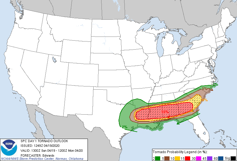
SPC tornado outlook for 4/12/20, above, compared to the outlook for 4/19/20, below: