Sorry to interrupt the Bachelorette, but my mind has been spinning frantically due to the recent deluge of severe weather. The meteorological setup for the last two weeks has been compared to some of the worst historical severe weather scenarios, including outbreaks in 2003 and 2011 that I remember well. The streak of “tornado days” (with 8 or more tornado reports) just ended at a staggering 13, the longest such streak since 1980. And the streak of consecutive days with a reported tornado anywhere in the U.S. is the longest since 1991. The sustained severe weather has been supported by a combination of factors: namely, a reasonably strong el niño influencing the jet stream, persistent cold air from the Rockies, and low-level moisture from a warm Gulf of Mexico and extensive surface flooding. The ingredients are in place for storms to form on repeat, with warm humid surface-level air wanting to change places with cold air aloft, accelerated by a curving jet stream. As the synoptic regime is covered extensively by recent press releases (shoutout to my colleague Dr. John Allen who was interviewed for practically every story), I find myself focusing on individual tornadic events, both to cope with the devastating losses to these communities and to understand the surface features that may have influenced the lifecycles of these specific tornadoes.
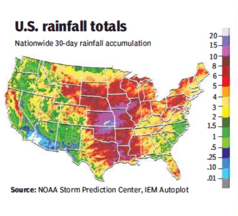
Before getting into the rundown, I must touch on the catastrophic flooding throughout much of the domain. Many parts of Oklahoma, Kansas, and Missouri have received 10 inches or more above normal rainfall during May, so the land that isn’t flooded has saturated soil and/or lush vegetation. It is indisputable that this abundance of surface moisture has fueled these severe weather outbreaks, as it is inconveniently located on the boundary between unseasonably warm air to the south and unseasonably cool air to the north. A stationary front has created a dangerous terrarium of sorts, incubating severe storms on the daily.
Key tornadic events:
5/18/19: The Texas panhandle was under a strong triple point as the stationary warm front parked over the Kansas-Oklahoma border. However, a few EF2 and EF3 tornadoes occurred farther south around Midland-Odessa and San Angelo, TX.
5/19/19: The high plains experienced elevated convection, to the glee of storm chasers. This is the best case scenario for severe weather, as magnificent footage was taken of tornadoes in western KS with no loss of life or property.
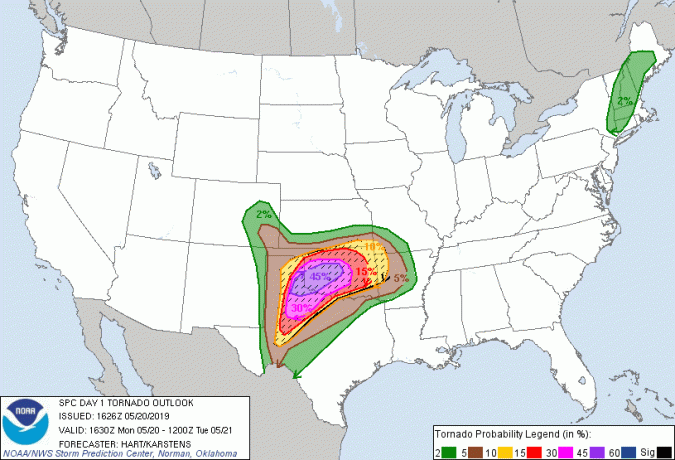
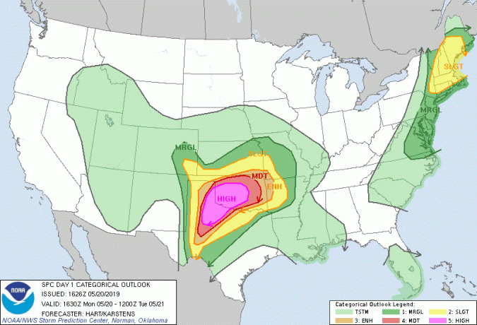
5/20/19: This was a high risk day for most of Oklahoma, but thankfully there were no injuries in the two EF2 tornadoes (Mangum, OK and Peggs, OK) or in the long-track EF1 in Pittsburg, KS.
5/21/19: A continuation of the previous day’s conditions spawned several QLCSs across eastern OK and much of MO. I was busy watching the radar in Springfield, since the largest tornado of the day was a long-track EF1 through the country 30 miles to the east of me.
5/22/19: The 8th anniversary of the Joplin tornado brought a scary situation: a storm that had previously spawned 2 tornadoes in Oklahoma intensified into an EF3 wedge about 5 miles to the north of Joplin. While no one in the Joplin area was harmed, there were 3 fatalities farther down the storm track in Golden City. The same night brought a devastating EF3 tornado to Jefferson City, damaging the capitol building and killing 4. Jay, OK was also hit by an EF2…so far the correlation between tornado touchdowns and towns has been noticeably high.
5/23/19: The tornado risk jumps back to the west as the southern edge of El Reno, OK is hit by an EF3. Again, it’s miraculous that there were no deaths considering that the tornado was strongest as it crossed I-40 and crashed through a motel. The small town of Laverne, OK was also spared as an EF3 lifted upon its approach.
5/24-26/19: The streak of tornado days was kept alive by virtue of multiple tornado reports on a couple of weak, hopping tornadoes. However, there was still significant damage incurred in Plainview, TX; Urbana-Champaign, IL; and Sapulpa, OK.
5/27/19: Dayton, OH was hit by the first of 3 scary supercells after sundown…an EF4 tracked all the way across the north side of the city, causing extensive damage and killing one elderly man. Nighttime tornadoes in urban areas are the ultimate nightmare scenario, but from what I’ve been reading, this disaster was handled exceptionally well at all levels. The other storms dropped EF2 tornadoes in Ohio and Indiana.
5/28/19: Another EF4 formed outside of Lawrence, KS and tracked to the western suburbs of Kansas City, doing its worst damage to Linwood, KS. Some positive news came from this storm, as Reed Timmer and his team were able to launch sensors into the tornado, collecting invaluable data on the conditions inside the vortex. Again, no deaths and 18 injuries seems incredibly lucky. An EF2 near Reading, PA headlined a smaller severe weather outbreak in the Mid-Atlantic.
5/29/19: Canton, TX was the epicenter of a few EF0-EF2 tornadoes, just 25 months after a rash of EF2-EF4 tornadoes hit near the town.
5/30/19: Finally, the streak of tornado days ends with a single EF0 report in Wisconsin.
Long-term forecasts show a probable shift in the jet stream, hopefully ending this prolonged pattern of severe weather. Of course I have been running the surface CAPE simulation over various domains throughout this weather pattern, and I have plenty of new cases. Preliminary model data shows some promising predictive results, but every forecast will need to be thoroughly cross-checked with other meteorological data from these events prior to publication. Coupled with data from storm chasers and a new release of topography layers by the USGS, I have quite a lot of data to sift through this summer.